Welcome to the stratigraphy section of the geology web pages. Arran has a wide range of rock types of different ages. When you place the rocks found on the island, in chronological order, you make a stratigraphic log. By clicking on the plus signs below, you can find out about the stratigraphy of Arran rocks.
1The Quaternary Period
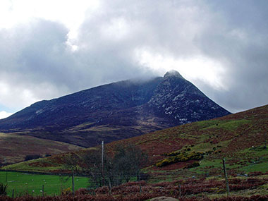
During the Quaternary glacial activity, the northern Arran granitic mountains were thought to be a centre of ice sheet accumulation in their own right from that of the Scottish Highlands (Sissons, 1976). The movement of the ice away from this centre eroded the mountains and gouged valleys to greater depths, thus producing classic U-shape valleys and hanging valleys, that can be seen in Glen Rosa (Image 1), and Glen Iorsa. The granite mountains of Arran have two distinct types of peak, the peaks to the east of Glen Iorsa have jagged, rugged, angular high peaks, some examples being Cir Mhor and Goat Fell (Image 2).
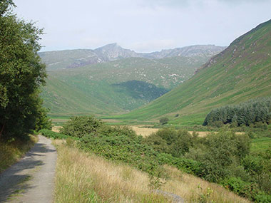
1. The U-shaped valley of Glen Rosa, with hanging valleys on either side and to the rear.
2. Beinn a Chliabhain-Cir Mhor-Goat Fell
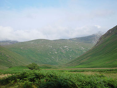
By contrast the western granite hills are more rounded, this is thought to have been related to more ice-sheet activity on the lower western mountains. At later periods in the glacial activity and the ice sheets were at lower heights, corries were developed on the northern sides of some of the peaks, i.e. the Devils punchbowl in Glen Sannox (Image 3.).
There abundant depositional features on Arran related to the Quaternary glacial action. There is abundant boulder clay covering the southern part of Island and some of the western part of the Island. Between Machrie and Dougarie, drumlin features have bee observed in the boulder clay. In the glaciated valleys of the northern granite mountains, abundant moraines can be found. These terminal and lateral moraines were the last deposits of the retreating valley glaciers (Image 4).
3. A Quaternary corrie on the north eastern side of Cioch na h-Oighe, locally it is called the Devil’s Punchbowl.
4. A glacial moraine deposit in Glen Rosa, the moraines are located on the floor of the U-shaped valley in a line of view with the tree in the foreground.
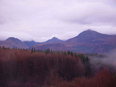
2 The Tertiary Period
a.) During most of the Tertiary except the very last part, basaltic dykes (with a range in compositions) were intruded into country rocks Image 1. In some places on Arran in particular around the coast at Kildonan, there are so many dykes to see, that they are called dyke “swarms” Image 2.
1. A Tertiary igneous dyke, cross-cutting Permian wind blown sediments at Corrie shore.
2. A tertiary dyke on the shore at Kildonan with the Isle of Pladda in the background.
b.) The next simplified sub-division of the Arran tertiary events/rocks, is thought to have occurred early in the Tertiary Period (ca. 63-60 million years ago), and involved the production of basalt plateau lavas, erupted through fissures. The only remnants of these lavas can be seen in the collapsed caldera of the Tertiary Central Ring Complex of Arran (see d below).
c.) The next Tertiary sub-division is the Northern Arran Granite unit/event (ca. 60.3-58.8 million years ago). A massive granite pluton forced it’s way up through the north of Arran, forming the northern Arran mountains (Image 3) and tilting and locally metamorphosing the Dalradian schists. The granite has a coarse grained inner portion and a finer grained outer portion. Associated with the northern granites are aplitic rocks and pitchstones intrusives.
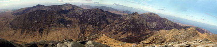
3. A view of some of the Granite Mountains of North Arran taken from Goat Fell.
d.) The fourth sub division of the Tertiary of Arran, is that of the Central Ring Complex, with ages at ca. 58.3 million years plus or minus 4.4 million years. During this time in the central area of Arran a volcano existed, the caldera of the volcano collapsed on itself and and there were other minor volcanoes within resurgent caldera. Many volcanic rock types were produced including granites, gabbros, felsites, basalts, andesites, pyroclastics and other volcanic rocks. During the collapse of the volcano of the Central Ring Complex, blocks of Jurassic and Cretaceous sediments fell into the collapsed caldera and are now the only remains of those sediments on Arran.
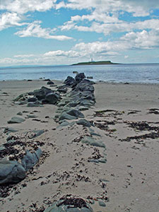
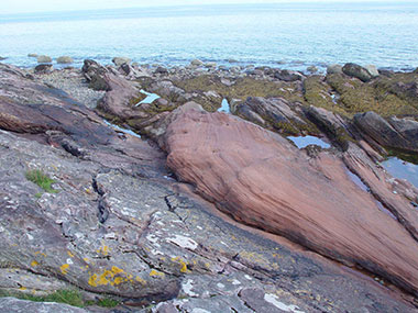
e.) The fifth general sub division of the Tertiary of Arran, can be said to have taken place at around 58.5 million years ago plus or minus 1.6 million years. during this time in the Tertiary the Ails Craig plug was formed, it is composed of a riebeckite granite, the Holy Isle Sill was formed Image 4 , the stunning Drumadoon Sill was formed Image 5, and the sill that the Isle of Pladda is partly composed of formed. numerous other acidic and basic sills and dykes were formed and a basic cone sheet formed as well.  4. A view of the Holy Isle from Arran, the main rock forming the Holy Isle is a Tertiary sill, composed of a riebeckite trachyte (akin to granite).
 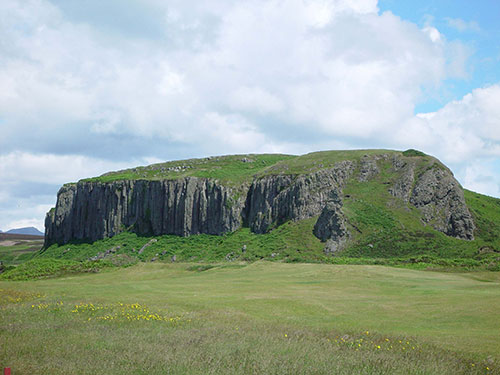 5. A view of the Drumadoon Sill, which displays beautiful columnarjointing and is composed of quartz-feldspar porphyry.
During the latter part of the Tertiary period on Arran, a lot of the Central Ring Complex was uplifted and eroded, erosion of the northern granite mountains also occurred.
3The Cretaceous Period
1. A cave at Creag na Feadh where a block of cherty Cretaceous limestone has been extracted over time for various uses, some of the limestone is still present.
4The Jurassic Period
5The Triassic Period
These rocks were thought to have been laid down in a lacustrine environment.
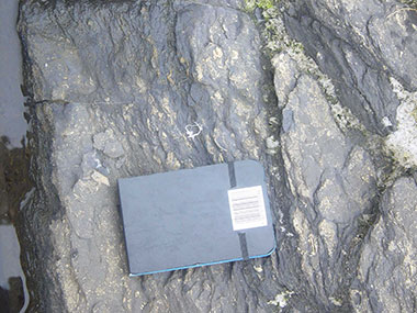
Image 1. Auchenhew beds outcropping at Levencorroch, the rocks are fine grained, clay rich, parallel bedded and lacking marine fossils.
2. Fine grained parallel bedded lacustrine Auchenhew Beds, exposed in the burn at Levencorroch.
3. Lacustrine Auchenhew Beds, exposed in the burn at Levencorroch. Desiccation cracks, suggest that the lakes in which they were deposited were impersistent (i.e. dried up on a regular basis).
6The Permian Period
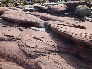
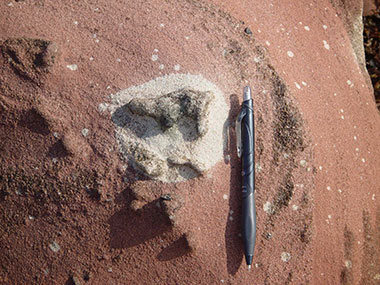
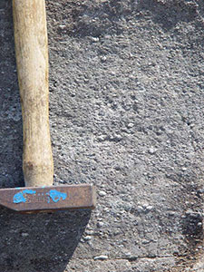
1. Corrie Sandstone (sub unit of the Brodick Beds), aeolian sandstones (Image 1).
2. Brodick Breccia (sub unit of the Brodick Beds), fluvial conglomerates.
3. Brodick Beds, aeolian and fluvial sandstones and conglomerates (Image 2).
4. Lamlash beds, aeolian and fluvial sandstones and conglomerates.
1. A junction between the Carboniferous river sands (on the left) and Permian wind blown sediments (on the right), on Corrie Shore.
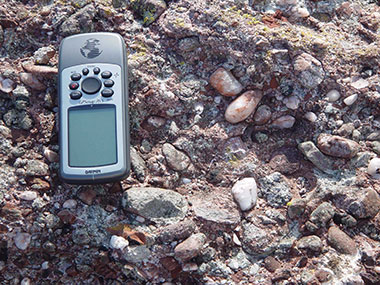
2. Permian sandstones and conglomerates (Brodick Beds), exposed on Brodick shore.
The lower fine grained sandstone beds are displaying cross-bedding.
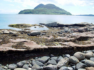
3. Permian sandstones (Lamlash Beds), exposed on Clauchlands shore. The Holy Isle is in the background.
7The Carboniferous Period
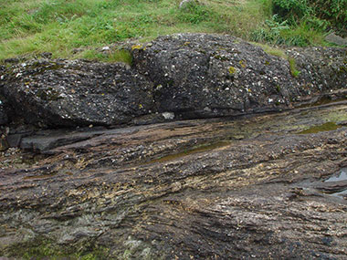
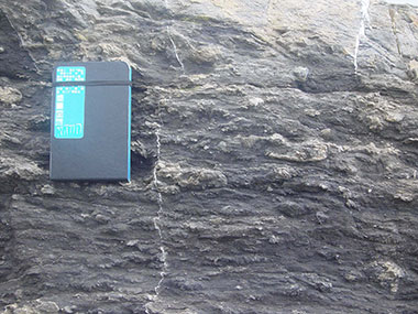
1. The Inverclyde Group (now including The Kinnesswood found at Hutton’s Unconformity), sands and mudstones with cornstones.
2. The Strathclyde Group, sands and shales above basalts lavas and mudstones.
3. The Lower Limestone Group, sediments laid down in deltas and limestones, some of the members of this group ar highly fossiliferous (Images 1 , 2 and 3).
4. Limestone Coal Group, sediments laid down in deltas and coals.
5. Upper Limestone Group, deltaic sequences with limestones.
6. Passage Group, fluvial (river) laid sandstones and volcanic ashes.
7. Coal Measures, river sediments and sediments formed in deltas with forests, these rocks contain abundant fossilised plant remains, including fossil rootlets and fossil tree roots (stigmaria) (Images 3 and 4).
1. A limestone bed at Laggan, a member of the Lower Limestone Group, containing abundant shells of the Brachiopod Gigantoproductus.
2. A limestone outcrop at Laggan, a member of the Lower Limestone Group, containing abundant fossils including crinoids, spiriferids, fenestella and zaphrentids.
3. A limestone outcrop at Laggan, a member of the Lower Limestone Group, containing abundant fossils including crinoids, spiriferids, fenestella and zaphrentids. The unit is fractured and calcite and sphalerite line the fractures.
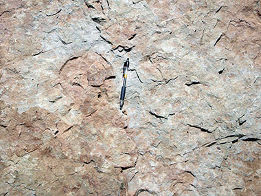
4. An outcrop of sandstone from the Carboniferous Coal Measures. It is exposed on the shore at Corrie and contains abundant fossilised rootlets.
5. An outcrop of sandstone from the Carboniferous Coal Measures. It is exposed on the shore at Corrie and hosts a fossil tree root or stigmaria (to the right of the pencil).
8The Devonian Period
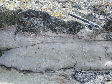
The Lower Old Red Sandstone of Arran outcrops in many places and is represented by conglomerates with rounded clasts of quartzite and vein quartz, red pebble rich grits and thin bedded sandstones and siltstones. During the interval between the deposition of the Lower Old Red Sandstone and the Upper Old Red Sandstone. The Lower Old Red Sandstone sediments were folded and underwent faulting due to major crustal movements, they were also denuded and eroded by the elements and in some locations completely removed. In Image 1 we can see an example of the Gavrock member of the Lower Old Red Sandstone, it is exposed in Glen Rosa, here it is green coloured as it has been altered. The iron in the coatings on the quartz grains has been reduced and has turned from red to green.
1. Lower Old Red Sandstone-Gavrock member, Glen Rosa
2. Cross-bedded ORS on Corrie Shore.
The Upper Old Red Sandstone is represented on Arran as red-cross bedded sandstones (Image 2) and siltstones and conglomerates hosting angular vein quartz and meta-sediment fragments, with some rounded quartzite fragments (Image 3). In some of the Upper Old Red Sandstone Units reduction spots can be seen (Image 4) and in-filled mud cracks can be also be noted.
3. An Upper Old Red Sandstone Conglomerate exposed on Corrie Shore.
4. A mud cast in the centre of a reduction spot on the surface of an Upper Old Red Sandstone Unit exposed at Corrie Shore.
9The Silurian Period
10The Ordovician Period
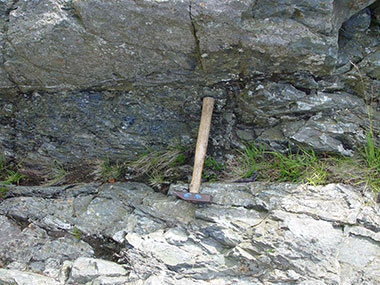
1. A contact in the North Sannox Burn, between Dalradian rocks and Ordovician rocks.
The hammer head rests on the Dalradian rocks and the shaft on the Ordovician black pyllites.
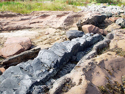
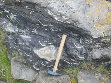
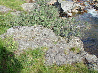
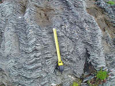
In Image 2, we can see the beautiful pillow lavas that were formed as basaltic lava issued onto the sea bed and cooled rapidly to form pillows. During the early Ordovician (Tremadoc age, 505-488 Ma) The Grampian Orogeny took place and the Dalradian sediments found on Arran underwent folding and metamorphism Image 3. The Grampian Orogeny was related to large scale plate tectonic events and readers should refer to Mckerrow et. al. 2000.
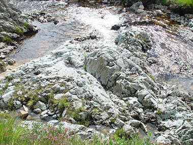
2. Ordovician (Arenig age) pillow lavas exposed in the North Sannox Burn.
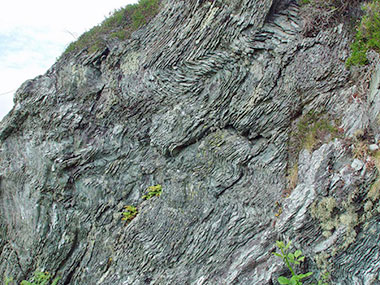
3. Folding in Dalradian Rocks due to the Grampian Orogeny that occurred during the Ordovician Tremadoc period.
11The Cambrian Period
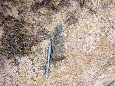
The oldest rocks on Arran are thought to have been laid down during the Lower Cambrian, they belong to the Southern Highland Group, in particular the Dalradian Subgroup. Similar Southern Highland Group rocks found at Callendar in Central Scotland, contained a fossil trilobite definitively age dating them to the early Cambrian. No such evidence has been found in the Dalradian rocks on Arran, but, it is likely that they were initially laid down during the Cambrian. The Dalradian rocks found on Arran were deposited on the bottom of a deep Ocean as sedimentary rocks such as greywackes , black muds and shales. They were laid down when the land mass that is now Arran was at a latitude of 27oN. These marine sediments have been classified as part of the Dalradian Subgroup which can be be seen outcropping in other parts of Scotland between the Highland Boundary Fault and the Great Glen Fault (Harris et. al., 1978).
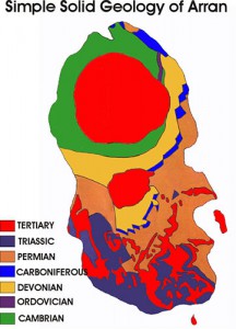
If we look at the simplified map of the solid geology of Arran, we can see that the Dalradian deep marine sediments occur on Arran in the northern part of the Island. After their deposition as marine turbiditic rocks, the Dalradian Rocks found on Arran have undergone metamorphism to produce metamorphosed greywackes and schists. This metamorphism was due to major geological events that were occurring during the evolution of the earth, in particular the Caledonian Orogeny, and took the Dalradian marine sediments to Chlorite grade metamorphism (that is, that they were cooked and compressed up to ca. 400°C temperature and 500 kilobars pressure), the Dalradian rocks on Arran were also folded when the Tertiary granite that forms the northern granite mountians of the island was emplaced.
Although the Dalradian metasediments on Arran have undergone a complicated geological history of metamorphism and deformations, it is still possible to see graded bedding in them (Image 1.) , this fining upwards of the sediment is typical of deep marine turbiditic sequences. Image 1, is a photograph of the Dalradian metamorphosed sediments found in the North Sannox burn just beside the road bridge and car park, where you can still see the coarser grains at the base of each depositional unit fining upwards. In other locations such as Imachar the original Dalradian sediments were more muddy and when they were metamorphosed a schistose cleavage was produced Image 2.
1. Graded bedding in a Dalradian greywacke.
2. Dalradian schists near Imachar, the original muddy deep marine sediments have been metamorphosed to produce shists with obvious cleavage planes.
The cleavage plains contain micaceous type minerals of muscovite and chlorite aligned in the same direction, this can easily be seen, by studying the rock down a petrological microscope Image 3.
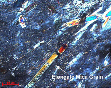
3. A view of some Dalradian Schist, observed down a petrological microscope.
In Glen Rosa Dalradian rocks can be observed in contact with Devonian rocks (Gavrock member of the Lower Old Red Sandstone) Image 4. This contact is thought by some to represent a possible extension of the Highland Boundary Fault, others have described the contact as an unconformity. You may want to go and have a look for yourself! There are numerous outcrops of the contact between the Dalradian rocks and the Tertiary Granite that forms the north Arran mountains. An example of the contact between Tertiary Granite and Dalradian can be seen in the North Sannox Burn Image 5. In other outcrops on Arran the Dalradian rocks can be seen to have been locally metamorphosed by the intruded granite, this is in addition to the general metamorphism of the Dalradian rocks during the Ordovician.
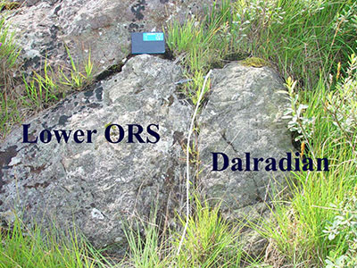
4. The contact between the Devonian Lower Old Red Sandstone and Dalradian in Glen Rosa.
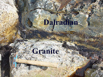
5. A contact between Tertiary Granite and Dalradian rocks, in the North Sannox burn.